North Delta Program

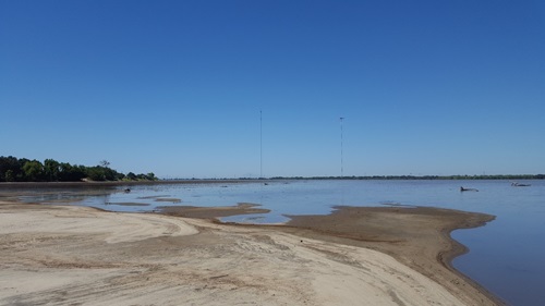
McCormack Williamson Tract after the 2017 winter floods, depicting the sand splay near the Mokelumne breach and interior flooded condition.
The North Delta Flood Control and Ecosystem Restoration Program (NDFCERP) consists of flood control and habitat improvements where the Mokelumne River, Cosumnes River, Dry Creek, and Morrison Creek converge. Flood flows and high water conditions in this area threaten levees, bridges, railways, and roadways that affect human safety and the economy.
The McCormack-Williamson Tract (MWT) and Grizzly Slough (GS) projects will reduce flooding and provide contiguous aquatic and floodplain habitat (nearly 2,000 acres) along the downstream portion of the Cosumnes River Preserve by modifying levees on MWT and GS.
The 2010 NDFCERP EIR (2010) proposed developing a flood control and restoration project (Alternative 1A) on MWT and GS with the following goals:
Flood
- Convey flood flows to the San Joaquin without immitigable stage impacts
- Reduce risk for catastrophic levee failure
- Control floodwaters through MWT to minimize “Surge” effect
Ecosystem Restoration
- Implement science-driven pilot program to restore natural processes and self-sustaining habitats (freshwater tidal marsh, seasonal floodplain, and riparian)
- Support special-status species
- Limit exotic species establishment
- Promote food web productivity
- Promote natural flooding processes and tidal action
- Promote processes that reduce subsidence
Recreation
-
Enhance public recreation in a manner that does not compromise flood protection infrastructure or operations, compromise habitat integrity, or disturb wildlife
The projects are consistent with the Delta Plan, Water Action Plan, and DWR EcoRestore and DFM Program objectives. The North Delta Project has a long history and considerable stakeholder support.


