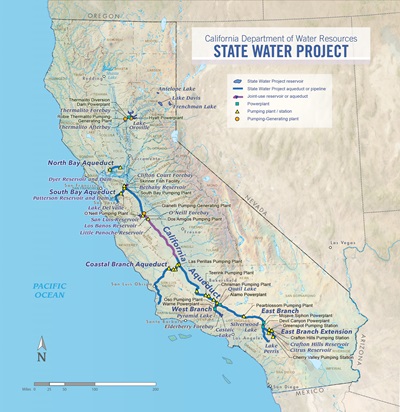
SWP Facilities
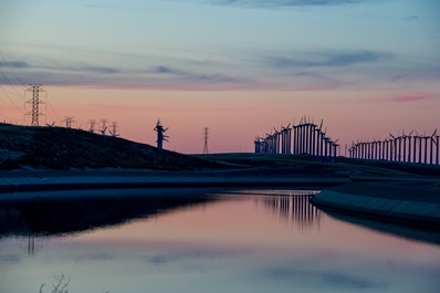
A spring evening over the California Aqueduct in the San Joaquin Valley.
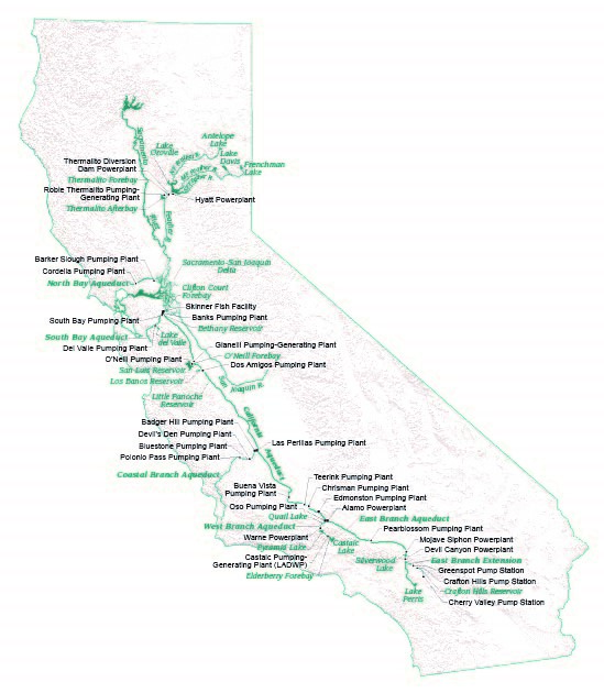
The California Aqueduct is the primary method of transporting water from Northern California to Southern California. The concrete-lined canal winds its way through the Central Valley, moving water from the Clifton Court Forebay in the Sacramento-San Joaquin Delta down to Lake Perris, the SWP’s southernmost reservoir. Water travels by gravity until it is lifted by pumping plants and then continues its journey south by gravity until the next pumping plant.
At the Tehachapi Mountains, water is lifted 1,926 feet by fourteen 80,000 horsepower pumps at Edmonston Pumping Plant. The Edmonston Pumping Plant is the highest single-lift pumping plant in the world. From the Tehachapi crossing, water flows into Antelope Valley, where the aqueduct divides into the West Branch and East Branch of the Aqueduct.The Coastal Branch Aqueduct, which provides water for San Luis Obispo and Santa Barbara counties, begins south of Kettleman City at Las Perillas Pumping Plant. SWP water travels through the Aqueduct to several pumping plants, including Badger Hill, Devil’s Den, Bluestone, and Polonio Pass. Coastal Branch Aqueduct ends at Tank 5 near Vandenberg Air Force Base.
The East Branch of the SWP carries water through Antelope Valley via Pearblossom Pumping Plant and Alamo and Mojave Siphon Powerplants into Silverwood Lake in the San Bernardino Mountains. From Silverwood Lake, water enters the San Bernardino Tunnel and drops 1,406 feet into Devil Canyon Powerplant. Water then flows to Lake Perris, the SWP’s southernmost reservoir.
Extending east into Riverside County via the East Branch Extension’s Foothill Pipeline, water is pumped at Greenspot Pump Station, then into Crafton Hills Reservoir and into Crafton Hills Pump Station. From Crafton Hills Pump Station, water flows to Cherry Valley Pump Station, where water is delivered to SWP water contractors or into spreading basins for groundwater recharge.
The North Bay Aqueduct transports water collected from Barker Slough in the Delta via the Barker Slough Pumping Plant. The water travels westward via underground pipeline to Cordelia Forebay. From the Forebay, the Cordelia Pumping Plant sends the water through underground pipelines to Napa County, Vallejo and Benicia cities, and Travis AFB.
The South Bay Aqueduct collects water from Bethany Reservoir in the Delta near Tracy, where the South Bay Pumping Plant lifts it 566 feet to the aqueduct’s twin pipelines and on to Patterson Reservoir. Some water from the reservoir is delivered to Livermore and the aqueduct transports the balance to Lake Del Valle. From Del Valle junction, South Bay Aqueduct continues to La Costa Tunnel, then Mission Tunnel and finally through the Bay Area hills to the Santa Clara Terminal Tank, east of San Jose.
The West Branch of the SWP takes water through Oso Pumping Plant into Quail Lake. From Quail Lake, water flows through the Peace Valley Pipeline to Warne Powerplant and then into Pyramid Lake in Los Angeles County. Water then flows through the Angeles Tunnel and Castaic Powerplant into Castaic Lake, the terminus of the West Branch.
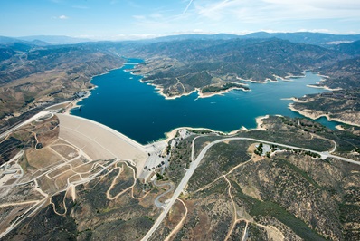
Castaic Lake and Dam, part of the State Water Project. DWR/2014
Antelope Dam and Lake are located entirely in the Plumas National Forest on Upper Indian Creek, a tributary of the Feather River’s North Fork. The facility was among five units initially authorized by the State Legislature in 1957 for water and recreation development in the Upper Feather River Basin. Construction began in 1962 and was completed in 1964.
The South Bay Aqueduct begins at Bethany Reservoir, located on the California Aqueduct, 1.5 miles downstream from Banks Pumping Plant. Construction of the forebay dam began in 1959 and was completed in 1961, with the adjacent dams and connection channel construction between 1965 and 1967.
Located about 45 miles northwest of Los Angeles and about two miles north of the community of Castaic, Castaic Dam and Lake were constructed between 1965 and 1974 to provide emergency storage during a shutdown of the California Aqueduct to the north, assuring deliveries from the West Branch. It also acts as regulatory storage for deliveries during normal operations and provides recreation for Southern California.
Situated in the San Bernardino National Forest east of Los Angeles, Silverwood Lake was formed in 1971 by the 249 foot high Cedar Springs Dam. Cedar Springs Dam and Silverwood Lake provide regulatory and emergency storage, help firm deliveries to users along the East Branch, provide recreation, and assure continuity of discharges through Devil Canyon Powerplant.
Clifton Court Forebay, located in the southwestern edge of the Sacramento-San Joaquin Delta, about 10 miles northwest of the city of Tracy, is a shallow reservoir at the head of the California Aqueduct. The forebay provides storage and regulation of flows into Banks Pumping Plant. Work started on the forebay in 1967 and was completed in 1969.
Part of the East Branch Extension (EBX) project, the Crafton Hills Dam is located in the city of Yucaipa, 10 miles east of San Bernardino. The initial phase, launched in 1999, completed construction of three pipeline reaches, the Crafton Hills Dam and Reservoir, as well as the Foothill, Greenspot, and Crafton Hills pump stations. Phase II included the new Citrus Reservoir and pump station, enlargement of the Crafton Hills Dam, and additional pipelines.
Located in Arroyo Del Valle, about four miles from the City of Livermore in Alameda County, Del Valle Dam and Lake Del Valle provide regulatory storage for the South Bay Aqueduct, flood control for Alameda Creek, conservation of storm runoff, recreation, and fish and wildlife enhancement. The facility was constructed from 1966 to 1968.
Elderberry Forebay, located on the upper end of Castaic Lake, provides regulatory storage which can be used by Castaic Powerplant for pumpback during off-peak hours, permits submergence for the pump-generator when the lake is at its lowest operating levels, and reduces daily and weekly fluctuations in Castaic Lake. The forebay was constructed between 1965 and 1974 by the Los Angeles Department of Water and Power, which also operates the facility. Elderberry Forebay has a maximum storage capacity of 32,480 acre-feet and also provides submergence of the pump-generator units when the lake is at its lowest operating levels. Elderberry Forebay is at the southernmost end of the West Branch FERC license boundary.
To the east of Lake Davis is Frenchman Dam, the tallest of the three Upper Feather River dams. Construction of the facility began in 1959 and was completed in 1961.
Located within the Plumas National Forest, Lake Davis and Grizzly Valley Dam lie on Big Grizzly Creek, a tributary of the Middle Fork of the Feather River. Water releases from Lake Davis fulfill prior water rights for agriculture, as well as provide fish and wildlife enhancement, recreation, and water supply for the city of Portola (eight miles south of Lake Davis) through the six-mile-long Grizzly Valley Pipeline.
Situated in Fresno County 20 miles southwest of the city of Los Banos, Little Panoche Detention Dam and Reservoir provide flood protection for San Luis Canal, Delta-Mendota Canal, and other downstream developments. Water is stored behind the dam above dead storage of 315 acre-feed only during the period that inflow from Little Panoche Creek exceeds the capacity of the outlet works. Construction of the facility occurred between 1965 and 1966.
Los Banos Detention Dam and Reservoir provide flood protection for San Luis Canal, Delta-Mendota Canal, the city of Los Banos, and other downstream developments. The facility is located on the west side of the San Joaquin Valley in Merced County, about seven miles southwest of the city of Los Banos. Construction began in 1964 and was completed in 1965.
Along the western side of the San Joaquin Valley in Merced County, the California Aqueduct enters O’Neill Forebay from the north. Constructed between 1963 and 1967, O’Neill Forebay offers a variety of recreational activities including camping, boating, windsurfing, and fishing.
Oroville Dam is the tallest earth-fill dam, at 770-feet, in the United States and forms Oroville Lake with a capacity of 3.4 million acre-feet (California's second largest reservoir). Oroville Dam and lake Oroville lie in the foothills on the western slope of the Sierra Nevada and are one mile downstream of the junction of the Feather River’s major tributaries.
The 33 foot high Patterson Dam located in Alameda County was completed in 1962 as part of the South Bay Aqueduct. As the terminus for the Livermore Valley Canal, Patterson Reservoir provides off-line storage for Alameda County Flood Control and Water Conservation District’s Zone 7 Treatment Plant.
Located in northwestern Riverside County, Lake Perris and Perris Dam lie about 11 miles southeast of Riverside and 60 miles southeast of downtown Los Angeles. Constructed between 1970 and 1974, the lake provides water supply for contracting users and fish and wildlife enhancement
Pyramid Dam and Lake are located on Piru Creek near Pyramid Rock, about 14 miles north of the town of Castaic along Interstate Highway 5. Construction on the dam and lake began in 1969 and was completed in 1973. The dam has a height of 400 feet, with a spillway for passing excess inflow into Piru Creek.
San Luis Reservoir, impounded by Sisk dam, lies at base of foothills on the west side of the San Joaquin Valley in Merced County, about 2 miles west of O’Neil Forebay. A second key conservation facility of the SWP, the reservoir provides offstream storage for excess winter and spring flows diverted from the Sacramento-San Joaquin Delta. It is sized to provide seasonal carryover storage. Construction began in 1963 and was completed in 1967. Filled in 1969, the reservoir also provides a variety of recreational activities, as well as fish and wildlife benefits.
Located about six miles southwest of the city of Oroville, Thermalito Afterbay is an offstream reservoir. The afterbay provides storage for the water required by the pumpback operation to Lake Oroville, helps regulate the power system, produces controlled flow in the Feather River downstream from the Oroville-Thermalito facilities, and provides recreation. The facility was constructed from 1965 to 1968.
Thermalito Diversion Dam forms the Diversion Pool, 13,328 acre-feet gross capacity, on the Feather River immediately downstream from the tailrace of Edward Hyatt Powerplant. Constructed between 1963 and 1968, the Diversion Dam and Pool are located about 4.5 miles downstream from Oroville Dam. The dam diverts water into the two-mile long Thermalito Power Canal, which transports water to the Ronald B. Robie Thermalito Powerplant for power generation, create a tailwater pool (called the Diversion Pool) for the Hyatt Pumping-Generating Plant; and provides headwater for the Thermalito Diversion Dam Powerplant.
Constructed between 1965 and 1968, Thermalito Forebay is an offstream reservoir contained by Thermalito Forebay Dam on the south and east and by Campbell Hills on the north and west. It is located about four miles west of the city of Oroville. The forebay conveys generating and pumping flows between Thermalito Power Canal and Thermalito Pumping-Generating Plant, provides regulatory storage and surge damping for the Hyatt-Thermalito power complex, and serves as a recreational site.
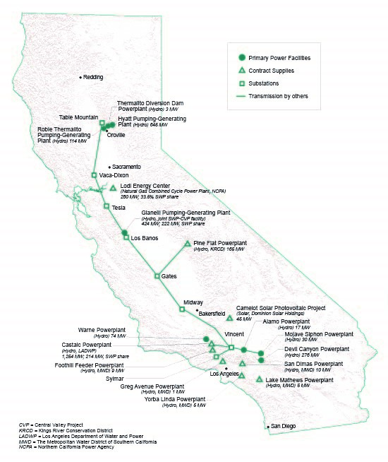
The Alamo Powerplant was constructed between 1982 and 1985 as part of the South State Water Project (SWP). The facility is located on the East Branch of the SWP, approximately 1.5 miles southeast of the SWP’s bifurcation into the West and East Branches. The powerplant generates electricity from SWP water flowing down the East Branch of the SWP.
Located about 40 miles northwest of Los Angeles between Pyramid Lake and Castaic Lake, Castaic Powerplant was designed, built, and operated under a cooperative agreement between DWR and LADWP. Unlike other facilities along the California Aqueduct, this pumping-generating plant is owned and operated by LADWP. Located at the northern end of Castaic Lake's west branch, regulatory storage for Castaic Powerplant is provided by Pyramid Lake and Elderberry Forebay. Castaic Powerplant has 7 generators with a maximum rated capacity of 1,275 megawatts. Construction began in 1969 and was completed in 1973.
Devil Canyon Powerplant is situated near the mouth of Devil Canyon at the southern base of the San Bernardino Mountains, about 5 miles north of San Bernardino. Constructed between 1969 and 1974, the powerplant generates electricity from water traveling through the plant from Silverwood Lake. The water is then discharged into two afterbays. The Devil Canyon Powerplant and Afterbays are at the southernmost end of the East Branch FERC license boundary.
Located about 12 miles west of the city of Los Banos adjacent to State Highway 152, the Gianelli Pumping-Generating Plant pumps water from O’Neill Forebay into San Luis Reservoir. Water is released through the plant in generating mode when service area demands are in excess of direct Delta diversions. Construction of the plant began in 1963 and was completed in 1967.
Located in rock in the left abutment near the axis of Oroville Dam, Edward Hyatt Powerplant is an underground, hydroelectric, pumping-generating facility. Construction of the plant began in 1964 and was completed in 1967. Hyatt Powerplant maximizes power production through a pumped-storage operation where water, released for power in excess of local and downstream requirements, is returned to storage in Lake Oroville during off-peak periods and is used for generation during peak power demands. Water from the lake is conveyed to the units through penstocks and branch lines. After passing through the units, water is discharged through the draft tubes to one free surface and one full-flow tailrace tunnel.
The Mojave Siphon Powerplant was constructed between 1990 and 1996 as part of the South State Water Project (SWP). The facility is located on the East Branch of the SWP in Hesperia, CA near Cedar Springs Dam and Silverwood Lake. The powerplant generates electricity from water flowing downhill after its 540-foot lift at Pearblossom Pumping Plant. Water travels down the open aqueduct until it enters three underground pipelines that carry the water under the Mojave River bed and the Las Flores Valley floor. SWP water flows into Silverwood Lake after passing through the Mojave Siphon Powerplant.
Ronald B. Robie Thermalito Powerplant is a principal feature of the Oroville-Thermalito pumped storage power complex. The facility is operated in tandem with Hyatt Powerplant and Thermalito Diversion Dam Powerplant to produce power. Water released for power in excess of local and downstream requirements is conserved by pumpback operation during off-peak hours through both powerplants into Lake Oroville to be subsequently released for power generation during periods of peak power demand. Construction on the plant began in 1964 and was completed in 1969, with operations starting in 1968.
Thermalito Diversion Dam Powerplant is located at Thermalito Diversion Dam below the left abutment of the dam. It was constructed between 1985 and 1987 and generates electricity from water released to the Feather River to maintain fish habitat between the Diversion Dam and Thermalito Afterbay river outlet. The plant facilities consist of intake headworks, inlet pipes, a single penstock, an underground powerhouse with one turbine unit, a tailrace channel and outlet works.
Warne Powerplant, in Los Angeles County near Pyramid Lake, was constructed between 1978 and 1982. The powerplant generates power by taking advantage of the 725-foot drop through the Peace Valley Pipeline to Pyramid Lake. This plant has 2 generating units with a maximum rated capacity of 75 megawatts.
Built as part of the Coastal Branch Aqueduct, Phase I, Badger Hill Pumping Plant is located three miles downstream from Las Perillas Pumping Plant and provides the second lift for delivery through the first 15 miles of the Coastal Branch. The plant’s construction took place between 1966 and 1968.
Located on the northwestern edge of the Sacramento-San Joaquin Delta, Barker Slough Pumping Plant marks the beginning of the North Bay Aqueduct. Its pumps lift water from Barker Slough into a pipeline that conveys the water to the Travis Surge Tank, nearly nine miles away. Water then flows by gravity to Cordelia Pumping Plant. Construction of the plant began in 1986 and was completed in 1987.
Constructed between 1994 and 1996, Bluestone Pumping Plant lifts water 1,500 feet in elevation through a buried 57-inch diameter pipeline to the summit of Polonio Pass of the Temblor Mountain Range. Its construction is similar to Devil’s Den.
Buena Vista Pumping Plant, constructed during 1967 to 1972, is located on the California Aqueduct, about 24 miles southwest of Bakersfield in Kern County. The plant operates in a series of sequential lifts in southern San Joaquin Valley with Teerink, Chrisman, and Edmonston Pumping Plants to convey California Aqueduct water to and across the Tehachapi Mountains. The Buena Vista plant provides a lift from elevation 295.4 to 500.6 feet.
Part of the East Branch Extension (EBX) project, the Cherry Valley Pumping Station serves as the terminal pump station and is located in Riverside County.
An in-land plant, Chrisman Pumping Plant is situated on the California Aqueduct, about 1.6 miles downstream from Teerink Pumping Plant. It operates in a series of sequential lifts in southern San Joaquin Valley with Buena Vista, Teerink, and Edmonston Pumping Plants to convey California Aqueduct water to and across the Tehachapi Mountains. Construction took place from 1966 to 1973.
Part of the North Bay Aqueduct, the Cordelia Pumping Plant is located in Solano County near Highway 80. It has three separate discharge pipelines. Two serve Benicia and Vallejo, and the third delivers water to the Napa Turnout Reservoir. Construction of the plant began in 1986 and was completed in 1988.
The Crafton Hills Pumping Station serves as one of three pumping stations part of the East Branch Extension (EBX) project, and is located in San Bernardino County.
Constructed between 1967 and 1969, Del Valle Pumping Plant pumps water during low demand periods from the South Bay Aqueduct into Lake Del Valle for storage and conveys it back to the aqueduct when demand is high and the water level is too low to allow flow back into the aqueduct via gravity. It actually serves as a booster station in the branch line between South Bay Aqueduct and Lake Del Valle. The plant lies immediately downstream of Del Valle Dam, about 4.5 miles south of the city of Livermore.
Devil’s Den Pumping Plant lifts water 1,500 feet in elevation through a buried 57-inch diameter pipeline to the summit of Polonio Pass of the Temblor Mountain Range. The plant was constructed between 1994 and 1996 as part of the Coastal Branch Aqueduct, Phase II.
Dos Amigos Pumping Plant is located on the San Luis Canal, about 10 miles south of the city of Los Banos and 18 miles southeast of Sisk Dam in Merced County. It lifts water 113 feet from the aqueduct as it flows south of O’Neill Forebay. The plant’s construction began in 1963 and was completed in 1966.
Constructed from 1967 to 1973, Edmonston Pumping Plant provides the largest lift, nearly 2,000 vertical feet, in the SWP system. The plant’s two main discharge lines stair-step 8,400 feet up the mountain side to a 62-foot-high, 50-foot-diameter surge tank. Near the top of the lift, 140 foot diameter valves can close each discharge line in the event of a system rupture and minimize water flowing back into the plant below.
Part of the East Branch Extension (EBX) project, the Greenspot Pumping Station is located in the city of Highland in San Bernardino County, and serves as one of three pumping stations part of the extension.
The Banks Pumping Plant lies in the southern portion of the Sacramento-San Joaquin Delta, almost 20 miles southwest of the city of Stockton. Marking the beginning of the California Aqueduct, the plant provides the initial lift of water 244 feet into the canal. During its construction from 1963 to 1969, seven pumps were installed. In 1986, four more were added to divert and pump more water during the wet months to fill offstream storage reservoirs and groundwater basins south of the Delta to improve water supply reliability.
Las Perillas Pumping Plant was constructed between 1966 and 1968 as part of the Coastal Branch Aqueduct, Phase I. It is located about one mile from the California Aqueduct and lifts water from the aqueduct for delivery through the first 15 miles of the Coastal Branch.
Located on the California Aqueduct, Oso Pumping Plant is the first major structure on the West Branch of the California Aqueduct. Constructed between 1967 and 1972, the plant lifts water 231 feet from Tehachapi Afterbay to Quail Canal which leads into Quail Lake.
Pearblossom Pumping Plant is located on the California Aqueduct, about 25 miles from the city of Lancaster and 12 miles east of the town of Palmdale. Constructed from 1967 to 1973, the plant lifts water about 540 feet to continue by gravity to Silverwood Lake.
Polonio Pass Pumping Plant is the third plant to sequentially lift water 1,500 feet in elevation through a buried 57-inch diameter pipeline to the summit of Polonio Pass of the Temblor Mountain Range. It was constructed between 1994 and 1996.
Located at the upper end of Bethany Reservoir, South Bay Pumping Plant lifts water into the first reach of the South Bay Aqueduct. It is situated in the north-eastern corner of Alameda County, about 12 miles west of Tracy. The plant’s stages construction took place between 1960 and 1969.
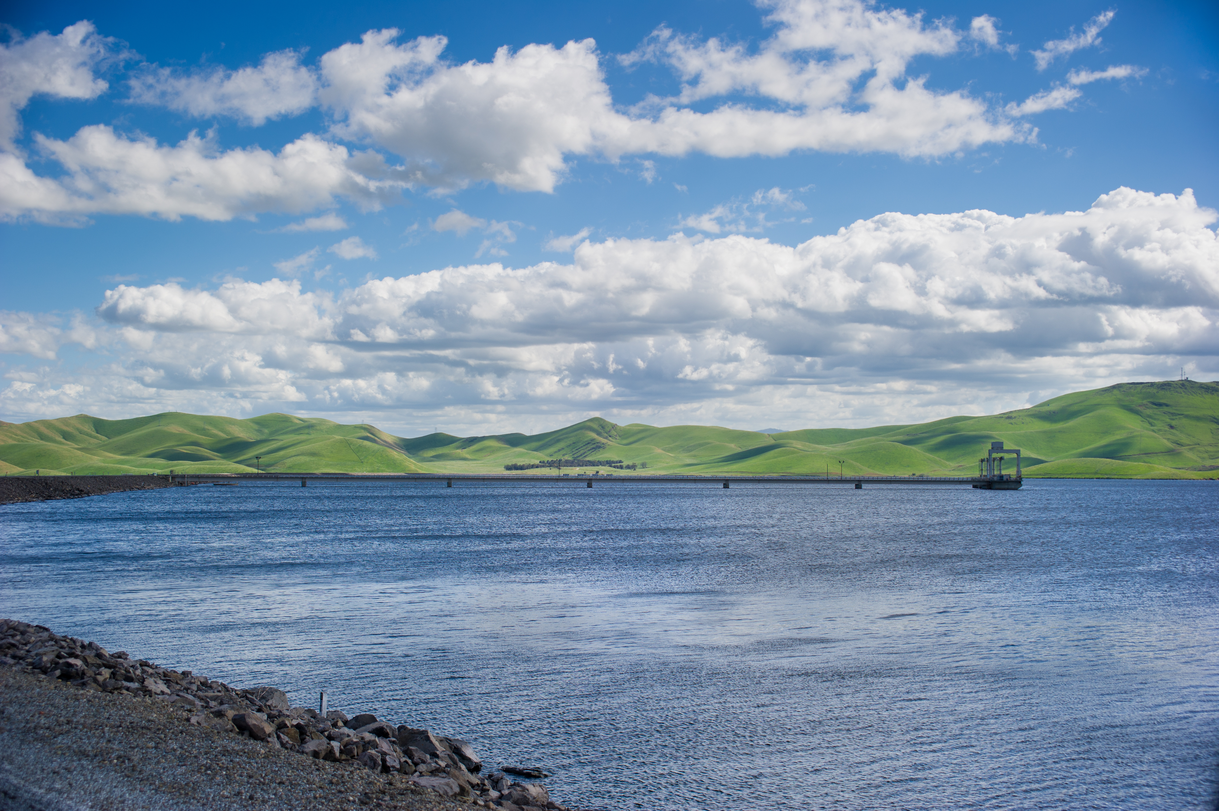
The San Luis Reservoir reached 98 percent of total capacity and 110 percent of historical average in Mach 2017. DWR/2017
Antelope Lake is located on the upper Indian Creek in Plumas County, a tributary of the North Fork Feather River, 43 miles from Quincy. The lake is part of the Upper Feather River Project within the Plumas National Forest, and was constructed to provide recreation opportunities, to maintain the natural beauty of the area, and to improve fish habitat in Indian Creek by assuring a constant, year-round flow of water below Antelope Dam.
Bethany Reservoir is located about 10 miles northwest of Tracy in Alameda County. The reservoir serves as a forebay for South Bay Pumping Plant and a conveyance facility in this reach of the California Aqueduct.
Located about 45 miles northwest of Los Angeles and about two miles north of the community of Castaic, Castaic Dam and Lake were constructed between 1965 to 1974 to provide emergency storage during a shutdown of the California Auqeduct to the north, assuring deliveries from the West Branch. It also acts as a regulatory storage for deliveries during normal operations and provides recreation for Southern California.
Clifton Court Forebay, located in the southern western edge of the Sacramento-San Joaquin Delta, about 10 miles northwest of the city of Tracy, is a shallow reservoir at the head of the California Aqueduct. The forebay provides storage and regulation of flow into Banks Pumping Plant. Work started on the forebay in 1967 and was completed in 1969.
Elderberry Forebay, located on the upper end of Castaic Lake, provides regulatory storage which can be used by Castaic Powerplant for pumpback during off-peak hours, permits submergence for the pump-generator when the lake is at its lowest operating levels, and reduces daily and weekly fluctuations in Castaic Lake. The forebay was constructed btween 1965 and 1974 by the Los Angeles Department of Water and Power, which also operates the facility.
Frenchman Lake is located on Little Last Chance Creek, a tributary of the Middle Fork Feather River, about 37 miles northwest of Reno and 26 miles northeast of Portola. The lake is part of the Upper Feather River Project within the Plumas National Forest, and was constructed to provide recreation opportunities, to maintain the natural beauty of the area, and to enhance fish habitat in the creek. Frenchman Lake also supplies irrigation water for Sierra Valley.
Lake Davis was constructed to improve fish habitat in the creek, provide recreation, and supply water to the city of Portola. It is the largest of the three Upper Feather River lakes, located on Grizzly Creek, a tributary of the middle Fork Feather River. The lake is part of the Upper Feather River Project within the Plumas National Forest, and was constructed to provide recreation opportunities and to maintain the natural beauty of the area.
Oroville Dam and Lake Oroville lie in the foothills on the western slope of the Sierra Nevada and are one mile downstream of the junction of the Feather River's major tributaries. The lake stores winter and spring runoff which is released into the Feather River to meet the Project's needs. Construction first began in 1957 on relocating what is now Highway 70 and the Western Pacific Railroad. Work on the dam site began in 1961. The embankment was topped out in 1967.
Constructed between 1970 and 1974, Lake Perris is the southernmost SWP reservoir and provides water supply, fish and wildlife enhancement, and recreation in northwestern Riverside County. Perris is one of the most popular recreational lakes in the SWP system.
Situated in Fresno County 20 miles southwest of the city of Los Banos, Little Panoche Detention Dam and Reservoir provide flood protection for San Luis Canal, Delta-Mendota Canal, and other downstream developments. Construction of the facility occurred between 1965 and 1966.
Los Banos Detention Dam and Reservoir provide flood protection for San Luis Canal, Delta-Mendota Canal, the city of Los Banos, and other downstream developments. The facility is located on the west side of the San Joaquin Valley in Merced County, about seven miles southwest of the city of Los Banos. Construction began in 1964 and was completed in 1965.
Along the western side of the San Joaquin Valley in Merced County, the California Aqueduct enters O'Neill Forebay from the north. Water from the Delta-Mendota Canal, part of the federal Central Valley project, is pumped into the forebay by the O'Neill Pump-Generation Plant. Construction between 1963 and 1967, O'Neill Forebay offers a variety of recreational activities including camping, boating, windsurfing, and fishing.
Pyramid Lake is about 16 miles north of the town of Castaic, on Piru Creek within the Angeles and Los Padres National Forests. The lake provides regulatory storage for Castaic Powerplant (owned and operated by the Los Angeles Department of Water and Power) and serves as an afterbay for William E. Warne Powerplant while supplying emergency storage for water deliveries from the West Branch, incidental flood protection, and recreation. Construction on the dam and lake began in 1969 and was completed in 1973.
Quail Lake, originally a pond created by a movement of the San Andreas Fault, was enlarged to move water safely across the fault. It receives off-peak flows from Oso Pumping Plant and provides storage. The lake also provides limited recreation and fish and wildlife habitat in the Tejon Ranch area of the western Antelope Valley, about 45 miles northwest of Lancaster and 70 miles north of downtown Los Angeles. Construction of Quail Dam and Lake took place during 1967.
San Luis Reservoir is 12 miles west of the city of Los Banos near the historic Pacheco Pass. San Luis is part of the San Luis Joint-Use Complex that serves both the SWP and the federal Central Valley Project (CVP). The complex comprises the recreational reservoirs O'Neill Forebay, San Luis Reservoir, and Los Banos Reservoir. Completed in 1967, San Luis Reservoir is one of the nation's largest offstream reservoirs, meaning it has no watershed. Instead, San Luis stores water diverted from the Sacramento-San Joaquin Delta for later deliveries to the Silicon Valley, San Joaquin Valley, Central Coast, and Southern California. Los Banos Reservoir is located on Los Banos Creek, about 7 miles southwest of Los Banos. It provides flood protection for San Luis Canal, Delta-Mendota Canal, City of Los Banos, and other downstream developments.
Thermalito Afterbay provides storage for the water required by the pumpback operation to Lake Oroville, helps regulate the power system, produces controlled flow in the Feather River downstream from the Oroville-Thermalito facilities, and provides recreation. Water may be pumped back into Lake Oroville through Ronald B. Robie Thermalito and Edward Hyatt Powerplants; released to the Feather River Channel; or diverted directly to the Sutter Butte Canal, Western Lateral, and Richvale and Western Canal. Thermalito Afterbay Dam has the longest crest in the State Water Project system at 42,000 feet long. The facility was constructed from 1965 to 1968.
Constructed between 1963 and 1968, the Thermalito Diversion Dam and Pool are located on the Feather River, about 4.5 miles downstream from Oroville Dam.The dam diverts water in Thermalito Power Canal for power generation at Thermalito Pumping Generating Plant and creates a tailwater pool for Hyatt Powerplant.
Thermalito Forebay, constructed between 1965 and 1968, is an offstream reservoir about four miles west of the city of Oroville. Thermalito Forebay is contained by Thermalito Forebay Dam on the south and east and by Campbell Hills on the north and west. It has a gross capacity of 11,768 acre-feet, and is formed by water releases from Lake Oroville and diverted by the Diversion Dam through Thermalito Power Canal. The forebay conveys generating and pumping flows between Thermalito Power Canal and Ronald B. Robie Thermalito Powerplant, provides regulatory storage and surge damping for the Hyatt-Thermalito power complex, and serves as a recreational site.
California State Water Project map of facilities located throughout California from Plumas to Riverside Counties. The map includes pumping plants, powerplants, pumping-generating plants, reservoirs, and the California Aqueduct.
